MEMS case study - farming software
Getting started using farming software solutions
There are many online or App based software platforms available to dairy farmers. Most require an annual subscription and capability and functionality vary, from simple mapping and manual record input to real-time GPS tracking and decision support tools informed by remote sensing technologies.
Deciding on what platform is going to make the most difference to your farm management, and the likely flow-on benefits to production, profitability and sustainability, can be overwhelming.
Consider what’s important
Making a list of benefits you are seeking is important. These may be:
- having a farm map with paddock boundaries and size (hectares), and other farm assets for improved planning
- tracking inputs at a paddock level — do I want manual or automated capability
- setting budgets against which actual records can be compared (i.e. fertiliser budgets)
- GPS files generated by tractor systems can be uploaded to mapping and database records (i.e. product, rate and precise location of application)
- easy identification of high-risk considerations (i.e. fertiliser buffers near waterways or withholding periods of products)
- multi-user access enabling employees to receive directions or make record entries from their smartphone
- forecasting capabilities to guide decisions on key managements such as grazing rotation (pasture forecasting), irrigation (soil moisture predictions) and timing of chemical and fertiliser applications (wind and rainfall forecasts).
Adopting new technology can take time and it’s best approached by taking transitional steps. Start by using just a couple of functions of the tool, then step-up usage over time as you become more familiar with the tools.
George Tiedeman
George Tiedeman, along with his father Guy, commenced leasing a farm at Dolly’s Flat (Wingham, NSW) in March 2023. He has a year-round herd of 220 cows on a mixed pasture milking platform comprised of 59 hectares of irrigation and 14 hectares of dryland.
In order to better plan and make decisions on the way the agronomy and irrigation of the farm is managed, George has worked with local agronomist, Josh Hack (Ag Farming Systems) to commence using two online platforms.
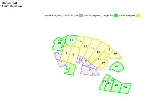
The first of these, “AgWorld”, has been adopted for annual pasture planning. After discussing the plan with George and Guy, the pasture plan was set-up by Josh on the platform to produce maps and records of the pasture species to be sown, timing of sowing and the associated costs.
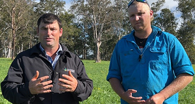
Josh Hack and George Tiedeman.
“It is really good as we all have a colour coded map that we can access on our phones showing us what seed and rate needs to go on what paddock. That way everyone is up to speed and we can get on with the job,” says George.
From the agronomist point of view, Josh can review exactly how the plan has been implemented remotely from his office. “For me, when I come onto farm, I already have confidence that what we planned to happen did actually occur, and we can get on with the next job at hand which is to manage the pastures to optimise yield,” he says.
The annual pasture plan is set-up in AgWorld to improve sowing scheduling, labour management and input cost planning. And this is when the second platform, “Pasture.io”, is used by George and his team. From their smartphones, the software allows them to enter information on what they are doing daily to manage the pasture.
“So far entering information hasn’t been too bad. We are still getting some of our staff up to speed. We can all see the entries that have been made by one another, so everyone knows what has been going on. It keeps everyone on the same page.”
The platform also keeps the agronomist up to speed.
“In terms of fertilising, spraying and when the cows have grazed, I know exactly how each paddock has been managed before I get onto the farm. George and I can then get directly out into the paddock when I arrive and pull-up the data to evaluate how the paddock is performing given the recent management, and make decisions going forward,” says Josh.
Pasture.io has functions that allow George to better plan his grazing management. Through the use of satellite imagery, NDVI (“greenness”) mapping is used to determine and predict pasture growth rate (KgDM/ha.day) and current available feed (KgDM/ha or TDM)
“I can see through the live maps or graphs that are generated where to next send the cows and how many grazings I can expect,” he says.
“Not only that, but I can also begin to use the data to understand how fertiliser applications and irrigation correlates with average growth rates across the farm. “In the longer-term I can decide where I can pull-back to save costs or increase inputs more precisely where needed.”
By applying fertiliser and irrigation only when and where needed, George is also reducing his risk of nutrient and sediment loss into nearby waterways.
Another risk managed is that of animal health. Withholding periods of fertilisers and sprays are auto generated when a product is entered into Pasture.io. A warning alarm will be triggered on the live map to ensure the paddock is not grazed within that period.
“This certainly eliminates accidental animal health risks,’ adds George.
While both tools still have a multitude of functions yet to be used by George, these first steps have provided a good foundation for his team and agronomist.
“We have plans to use GPS capabilities in the future to monitor the location of fertiliser and spray applications in AgWorld. This will certainly increase further my ability to keep track of where and when inputs are needed and evaluate how effective they have been on driving yield and reducing unnecessary costs and losses.”
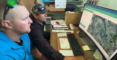
Josh Hack and George Tiedeman review the paddock data of Pasture.io in the farm office.
Other resources
Towards better nutrient accounting on dairy farms
Watch George Tiedeman and Josh Hack overview the platforms being used on the Wingham, NSW farm to increase the efficient use of nutrients and better inform pasture management decisions.
Getting value from Fert$mart nutrient planning
Watch the video on how George and Guy Tiedeman use a Fert$mart Plan to increase nutrient use efficiency and profitability.
For more information
Contact your nearest Local Land Services office on 1300 795 299.
Download a PDF copy of the Farming sotware case study PDF, 347.67 KB.
You can also read more about Guy and George Tiedeman and what they are doing on their farm.
This project is being delivered by Local Land Services as part of the Clean Coastal Catchment (CCC) Project. The CCC Project is funded through the NSW Government’s Marine Estate Management Strategy.