Protecting Our Wetlands
There are a number of threats to wetlands including vegetation clearing, draining, overgrazing by livestock, contamination from excessive pesticide and fertiliser use, the presence of pest animals and plants such as carp, pigs and willows and the expansion of urban areas.
What can I do to protect wetlands?
You can support healthy wetlands in a variety of ways:
- minimise disturbance to wetlands on your property
- erect fences to manage stock access to wet areas
- establish a buffer zone between your wetland and grazing or cropping land
- practice conservation farming techniques, including good chemical management
- form or join a community group to care for a wetland near your town or city
- avoid clearing dead wood and trees from wetlands as they provide valuable native habitat
- monitor the wetland area for weeds and pest animals regularly
- restore wetlands and natural water flows, communicating your plans with your local community where possible
- encourage native vegetation to grow in and around wetlands
- allow low-lying back swamps to fill and drain naturally so they can provide productive native grazing species such as water couch
- organise regular clean-up activities at your local wetland.
Celebrating the diversity of wetlands
February 2nd is World Wetlands Day, a day to celebrate and recognise the vital role wetlands play in many aspects of our lives. Wetlands are valuable ecosystems home to many fascinating and threatened plants and animals.
Learn about wetlands in our different regions
Wetlands in the Murray region
Celebrating the diversity of wetlands in the Murray region: World Wetlands Day 2023
Within the NSW Murray region, wetlands play an integral part in the functioning of the Murray Darling Basin. Our community plays an essential role in protecting and enhancing wetlands, with Murray Local Land Services working with local community groups, fishing clubs and aboriginal groups to improve populations of threatened wetland specialist fish species.
In the far east of the region, Montane Peatlands feature in the headwaters of the catchment at high elevations, forming large stores of carbon through the accumulation of organic matter over thousands of years. These fragile ecosystems have developed unique plant and animal communities that are vulnerable to changes in climate, pest animals, weeds and grazing. Murray Local Land Services has been working to protect the critically endangered Bago Leek Orchid and Kelton’s Leek Orchid on properties in sub-alpine areas east of Tumbarumba through exclusion fencing, weed control, and pest animal control.
At lower elevations, floodplain wetlands and billabongs feature across river and creek systems, relying on seasonal or managed flows to fill. Seasonal drying is an important characteristic, particularly for rain-filled wetlands, which are common on farming properties across the region.
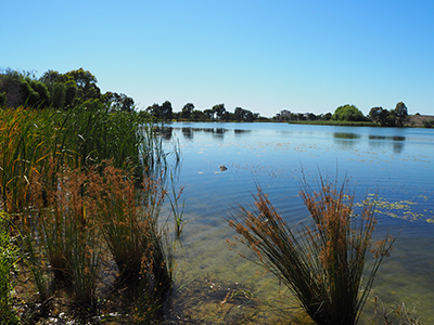
Photo: Moulamien Lake
Wetlands for Wildlife Project
The Wetlands for Wildlife project is working with landholders to improve wetland habitat for threatened species, including White-bellied Sea-Eagles and Southern Bell Frogs, through changes in:
- grazing management
- fencing
- revegetation;
- and infrastructure to deliver water.
Enhancement of NSW Central Murray Forests Ramsar Site Project
The NSW Central Murray Forests is an internationally significant site listed under the Ramsar Convention for its uniqueness and biodiversity values. The site encompasses the Millewa, the Werai and the Koondrook-Perricoota (KP) Forests, totalling approximately 90,000 Ha. In its 5th year, the Enhancement of NSW Central Murray Forests Ramsar Site project has invested in targeted fox baiting, weed control, revegetation works and exclusion fencing targeting specific wetlands such as Yadabal, Pollack and Little Forest.
Large-scale pest control works for KP and Millewa have included aerial shooting of feral deer and pigs and fox baiting. Evidence suggests that intensive fox baiting reduces turtle nest predation, and the project team were excited to find juvenile turtles for the first time recently during annual surveys following long-term baiting at Pollack Swamp.
Threatened Native Fish Recovery Program
The Threatened Native Fish Recovery Program aims to breed Eel-tailed catfish, Southern pygmy perch, and Southern purple spotted gudgeon in surrogate wetlands with the view to eventually release them into local wetlands and river systems. Monitoring has shown the threatened species are doing well in their surrogate homes, with Eel-tail catfish numbers improving enough to relocate some to additional sites.
Opportunities to get involved
The theme for World Wetlands Day 2023 is ‘It’s time for wetland restoration’, highlighting the fast rate at which we are losing wetlands globally (35% in the last 50 years) and putting forward a call to start a restoration trend.
Within the Murray region, there are many great examples of landholders and community groups working hard to prevent the loss of wetland habitat. With 6,350 wetlands within the region, 78% of which are privately owned, there are significant opportunities for private landholders to take action to protect and restore wetlands on their property.
Some management actions include:
- Changing grazing regimes to exclude stock or restrict grazing to certain times of the year
- Controlling aquatic and terrestrial weeds.
- Controlling pest animals such as foxes, feral pigs, rabbits and deer.
- Planting locally native aquatic and riparian plant species and allowing natural vegetation regeneration.
- Enhancing farm dams to provide habitat for aquatic fauna.
Other opportunities for individuals to become involved include:
- Local initiatives: Join your local Landcare or ‘Friends of’ group to participate in field days and workshops and learn about your local area.
- Citizen Science: Download the FrogID app and record frogs in your local area to provide valuable data to scientists to help protect frogs.
- Tread lightly: Enjoy your local wetlands responsibly by avoiding littering and not feeding birds.
For more information on wetland restoration and ways to get involved, call Murray Local Land Services on 1300 795 299.
Wetlands in the North West region
Above average rainfall across North West NSW in 2022 has resulted in ideal conditions for outbreaks of water weeds such as the water hyacinth. Water hyacinth impacts waterways including the Ramsar-listed Gwydir wetlands in which it smothers the surface, reduces quality, and lowers oxygen levels in the water.
Moree Plains Shire Council, with our support, have been monitoring and controlling water hyacinth in the Gwydir wetlands, an important waterbird breeding ground, for three years.
Council have been actively monitoring and controlling outbreaks as they occur, using drones and helicopters for access when sites are inundated. It is important to keep monitoring for outbreaks of water hyacinth, as wet years can see infestations grow rapidly, making them difficult to control if left unchecked.
North West Local Land Services, through funding from the National Landcare Program, supports land managers to reduce weed threats within the wetland area.
Find out more about our Collaboration to Build Character of Ramsar Wetlands.
Wetlands in the Central Tablelands region
Considerable El Niño driven rains have recharged aquifers that feed wetlands on Newnes Plateau. However, it can be a case of too much of a good thing. The Swamped By Threats project manages perched wetlands and upland swamps in the Blue Mountains and on Newnes plateau. All the recent rain has meant the Swamped by Threats team has needed to look at ways to manage water entering natural systems and stabilise eroding channels.
Works are currently occurring at Browns Swamp to reduce the erosive force of water at the top of the swamp and return surface flows to groundwater. Installation of a sediment basin, infiltration pit and drop-structures will improve the resilience of the wetland to both drought conditions and high-rainfall events.
Find out more about the Swamped by Threats project.
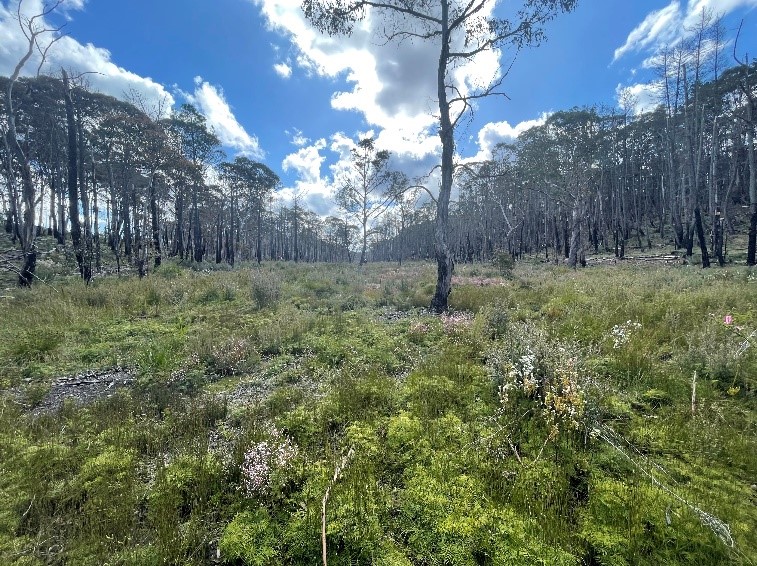
Photo: Newnes Plateau Shrub Swamp Community; Boronia deanei in flower.
Wetlands in the Greater Sydney region
To celebrate, we wanted to showcase the work we are doing to improve habitat and control pests and weeds at Towra Point Nature Reserve.
Consisting of 386.5 ha of wetlands, including mangroves and saltmarsh, Towra Reserve supports critical biodiversity for many fauna species, particularly migratory shorebirds.
This five-year Ramsar project has engaged with many stakeholders to complete on-ground works to improve habitat, control feral animals and weeds as well as engage and educate the local community on the value of these habitats.
Our NRM team recently visited the reserve to undertake annual vegetation surveying in saltmarsh and Littoral Rainforest. Many transects were established at the beginning of the project and each year, LLS undertakes a survey at each transect, recording the plant species present within a 2-metre square quadrat at every 10-metre interval. These surveys help to assess change over time, gauging the number of native species compared with weed species, thereby showing positive or negative change to the habitat.
Find out more about the Towra Point nature reserve project.
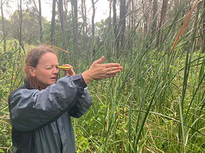
Photo: Liz measuring direction amongst reeds and sedges
Wetlands in the North Coast region
Wetlands contain plants and vegetation communities that are unique. One of these unique wetland plant communities is the Coastal Swamp Oak Forest. This once prolific vegetation type was common across the coastal floodplains of the North Coast. However, clearing and fragmentation; weeds; grazing; flood mitigation and drainage works have taken a toll. Now it is estimated that only around 20% of these forests remain and much of this is patchy and degraded.
Coastal Swamp Oak Forests are a Threatened Ecological Community that is now listed as Endangered in NSW and SE Queensland. These unique areas are often home to rare animals including greater gliders, brush-tailed phascogales, grey-headed flying foxes and even koalas.
With partnerships supporting landholders to protect and enhance the Coastal Swamp Oak Threatened Ecological Community, we hope to reverse the loss of these amazing wetland forest habitats.
Find out more about how you can help protect wetlands contact us on 1300 795 299.
Wetlands in the Riverina region
The Riverina is home to many wetlands including our very own internationally recognised Ramsar listed Fivebough and Tuckerbil wetlands and the mid and low bidgee. These are wetlands of national significance with many providing habitat for an array of threatened species including the iconic Australasian Bittern, Painted Snipe and Southern Bell Frog
Predation by feral animals has been identified as a key threat, with ongoing control measures being undertaken and camera tracking at Fivebough indicating a significant drop in the numbers of cats and foxes. Pig control measures in the low bidgee have also resulted in a substantial drop in population numbers.
Working to improve habitat conditions and actively manage identified wetlands for Australasian Bitterns has been an important aspect of the Boosting the Bunyip Bird Yield project with funding through the National Landcare Project.
Find out more about saving the Australasian Bittern.
Wetlands in the Hunter region
Stockton Sandspit - shorebird rehabilitation
The sandspit is a site on the East-Asian Australasian Flyway, part of a Ramsar Wetlands of International Importance and covered by three international treaties protecting migratory bird habitat.
Since the 1970s shorebird numbers have more than halved in the Hunter River estuary as roosting sites have become unsuitable due to development and encroachment by mangroves and weeds. Given the declining value of the site as a shorebird roost, it was recommended that Stockton Sandspit be rehabilitated.
Kooragang Wetland Rehabilitation Project (KWRP)
KWRP began works on the sandspit in the mid 1990s and successfully reduced damage by vehicles, cleared weeds and created wader habitat for foraging and roosting with a lagoon and island with saltmarsh surrounds.
Bird response was positive but not optimal as fringing mangroves were still obstructing the view for birds using the site. Hunter Bird Observers Club recommended removal of half a hectare of mangroves from the beach edge and National Parks and Wildlife Service removed these mangroves in 2002. As a result, thousands of shorebirds returned to the sandspit during the 2002/03 season.
With on-going maintenance by bird observers, the sandspit has been reinstated as part of the most important shorebird roost in NSW and one of the largest concentrations of shorebirds in Australia close to a major city and industry.
The most visible birds are Red-necked Avocets which flock to the sandspit in great numbers. Less visible but of great international importance are long-distance migratory species including Eastern Curlew, Sharp-tailed Sandpiper, Bar-tailed Godwit, Black-tailed Godwit, Curlew Sandpiper and Red-necked Stint.
The sandspit is an iconic site for Newcastle and the Hunter Region in bringing biodiversity to a coastal city and being accessible to many bird enthusiasts who are often rewarded with easily visible migratory waders in great numbers.
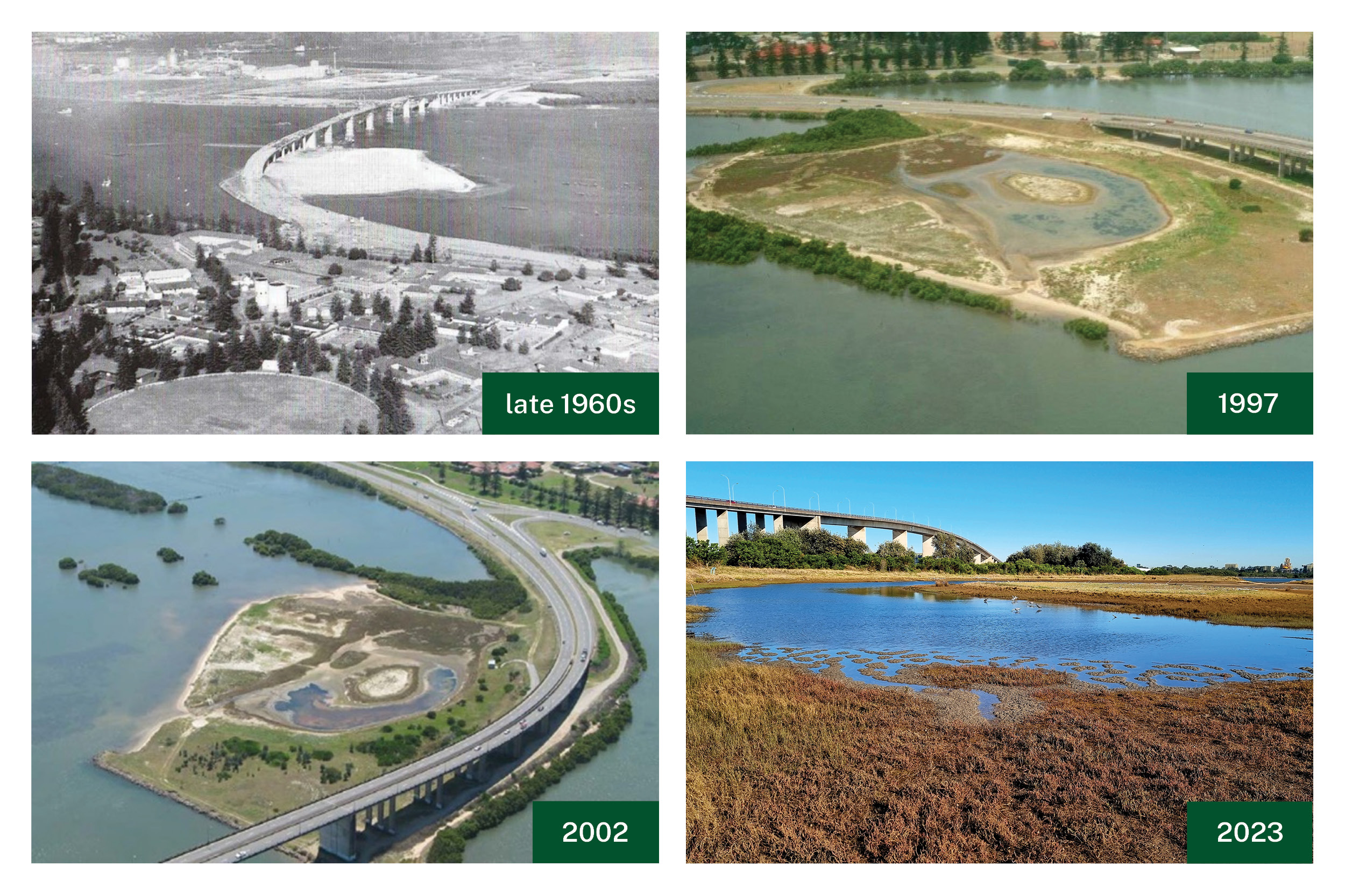
Aerial photos show changes over time from the late1960s to the present.
Visit Hunter Bird Observers Club for more information on migratory bird sites in the Hunter estuary Hunter Bird Observers Club (hboc.org.au)
Black-necked Storks
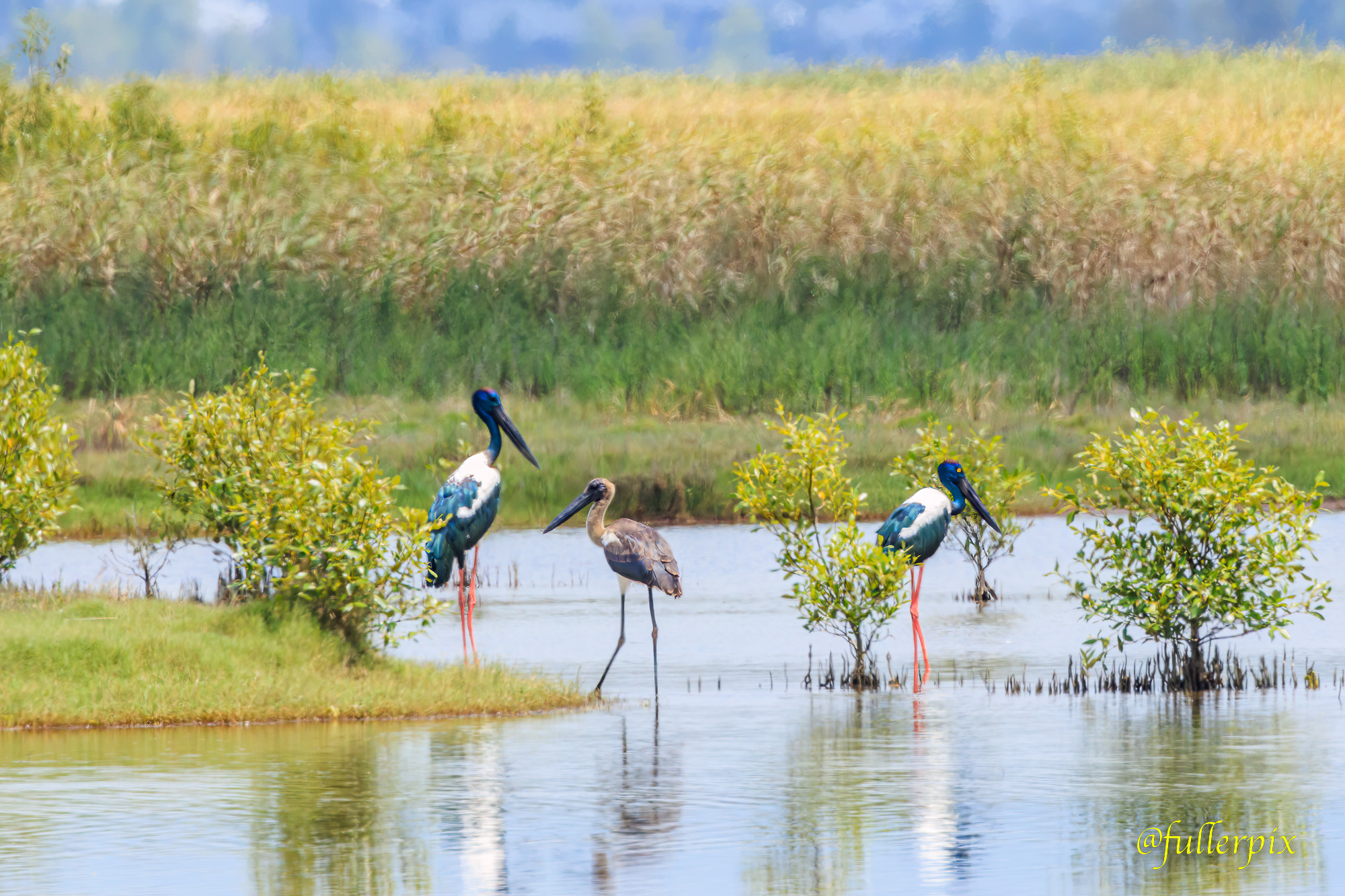
Photo courtesy of Paul Fuller
We are very excited to see the resident pair of Black-necked Storks with their young, in Hexham Swamp this week, wonderful photo by Paul Fuller. The Storks returned to the swamp a few years ago due to ideal habitat conditions and a plentiful food supply including fish, frogs and eels.
Hexham Swamp Rehabilitation Project has successfully rehabilitated a mosaic of valuable wetland habitats due to re-instating tidal inundation at Ironbark Creek floodgates. The Project was initiated over twenty-five years ago and environmental monitoring continues today, managed by Hunter Local Land Services.
An increase in mangroves, saltmarsh, open water and mud flats provides nursery habitat for juvenile fish and prawns and important habitat for waterbirds, including migratory shorebirds that fly from the northern hemisphere every year for the summer migration.
Find out more by watching this video.
Wetlands in the Northern Tablelands region
Some of the Upland Wetlands on the Northern Tablelands are continuing to enjoy favourable wet conditions which are greatly assisting researchers who are continuing to monitor ‘conditions and critters’ within these Endangered Ecological Communities. Little Llangothlin Nature Reserve is open to the public and is hosting a Day in the Life of a Wetland on 25 February.
Find out more about a day in the life of a wetland event.