Riparian and In-Stream Works Community Guideline
Introduction
This guideline is a decision-making tool to assist members of the community to understand and obtain approval for riparian and in-stream works, being works within and/or adjacent to a waterway including freshwater waterways, rivers, and estuaries. The guideline predominantly relates to riparian and instream works including erosion protection and remediation.
A supplementary guideline titled ‘Technical Guideline - Riparian and In-Stream Works’ has also been developed to assist Local Land Services personnel to understand and obtain approval for riparian and in-stream works.
Note that Government legislation, policy and guidance regarding environmental assessment, approvals and permits is subject to change. While this guideline can be used to assist in mapping out the approval pathway in relation to a riparian and/or in-stream works project, it does not substitute consultation with relevant government authorities and consideration of up-to-date legislation, regulation, policy, and guidance. Each site is assessed on a case-by-case basis.
In the instance where information is not known following your review of any relevant section of this guideline, it is recommended that you undertake consultation with your Local Council, Local Land Services Office in your region, other applicable government department as outlined within this guideline or a specialist environmental planning consultant.
How to use this Guideline
This guideline is intended to be read on a ‘step by step’ basis. Each section of this guideline provides information in relation to a particular step in the environmental assessment process. Through navigating each of the relevant steps, it is possible to map the approval pathway in relation to any riparian and/or in-stream works project.
- Summary: This section will list the approval pathway for the riparian or in-stream works based on consideration of the steps below.
These steps can be grouped into 3 key categories:
- Steps 1 – 3 and 11 – 13: These steps apply to any project and/or include considerations that will fundamentally determine the nature of the approval pathway, such as whether an existing exemption applies to the proposed activity.
- Step 4: If triggered, this is an overall assessment framework which will require consideration of steps 5 – 10 as applicable. (Note: Steps 5-10 still required if Step 4 is not applicable)
- Steps 5 – 10: These steps include consideration of specific aspects of a proposal, such as works within 40m of a waterway, impact to important fish habitat and impact to threatened species and communities. These aspects are generally unique to a specific project site and can be triggered based on factors such as the environmental or cultural heritage significance of a particular location.
Step 1: Who Owns the Land and Adjoining Properties?
Step 2: Will the Work Impact Upon Mapped Coastal Wetland or Littoral Rainforest?
Step 3: Are the Works Exempt or Complying Development or Works Permitted Without Consent?
Step 4: Development Application
Step 5: Are the Works a Controlled Activity?
Step 6: Do the Works Impact Upon an Area Subject to Coastal Management Considerations?
Step 7: Do the works impact upon key fish habitat and/or fish passage?
Step 8: Do the Works Impact Upon Aboriginal Object(s) or Declared Aboriginal Place(s)?
Step 9: Do the Works Impact Upon Non-Aboriginal Heritage?
Step 10: Do the Works Incorporate Impact to Native Vegetation and/or Endangered, Threatened, Vulnerable or Protected Species, Populations, Ecological Communities or Area of Outstanding Biodiversity Value, or represent a Key Threatening Process?
Step 11: Do the Works Impact Upon Matters of National Environmental Significance?
Step 12: Other Consideration
Step 13: Stakeholder Consultation
Step 1: Who Owns the Land and Adjoining Properties?
Determine the ownership of the land where the works are proposed and adjoining properties.
For example, does the land fall under the ownership or management of:
- Private ownership - Written consent and other agreements from the landholder may be required. Undertake consultation and obtain formal consent from the landholder to undertake the works. In the instance where works are undertaken on land under private ownership, it should be ensured that appropriate insurances, deeds and land access agreements as applicable are in place prior to the commencement of any works.
- The Crown - The beds of most tidal waters and non-tidal waters includes Crown Land. Though the physical water boundaries can move from natural causes such as erosion, the current land title may not necessarily reflect the location of the actual boundary. Complete a water boundary determination to determine if the proposed works is on Crown Land. Requirements for DPE-Crown Lands, Land owners consent and/or authorisation by DPE – Crown Lands must be considered where proposing works or activities on Crown land, Crown waterways or Crown roads.
Note: Crown Lands may require the short term license or general license applicant to have public liability insurance with an excess of $20 Million - Council – Written consent and other agreements and/or approvals from Council may be required. Consult with the relevant Council to determine requirements.
- National Parks and Wildlife Service, including land managed under the National Parks and Wildlife Act 1974 – Includes working within a national park, nature reserve, aboriginal area, wilderness area, conservation area or wild river working adjacent to land reserved under the National Parks and Wildlife Act 1974. Special provisions for works in these areas may apply.
- State Forest or area subject to Forest Agreement – Approval to undertake works on this land may be required from the Forestry Corporation of NSW.
- Other Government Departments (such as Transport for NSW) – Consult with the relevant government department and obtain necessary agreements and approvals.
- Land subject to land rights claims or Registered Native Title or Register of Indigenous Land Use Agreements - Approval or consent to undertake works on this land is likely to be required. Consult with the relevant Native Title organisation or Aboriginal Land Claim group.
- Multiple landowners - works located on the bank of a waterway often have a footprint that covers multiple tenures e.g., Crown tidal/intertidal land and private land above mean high water mark. In such instances, landowners consent will be required from all landowners within the footprint of the works. The NSW Governments ePlanning Spatial Viewer may be used to assist in determining property address, legal property description and land ownership details.
If you are unable to identify land ownership details through available information, consult DPE – Crown Lands and/or your local council for further assistance.
Also consider the presence of any Easements, Rights of Way, Plans of Management or any Native Title requirements or Aboriginal Land Claims that may apply. This information may be obtained from the formal property plans (available from the relevant local council), the ePlanning Spatial Viewer or through consultation with the relevant landowner or land management stakeholder. Note: Also refer to relevant consultation requirements under ‘Step 13’.
Step 2: Will the Work Impact Upon Mapped Coastal Wetland or Littoral Rainforest?
| Yes | No |
|---|---|
The works are classified as ‘Designated Development’.1 An Environmental Impact Assessment may be required. If classified as ‘environmental protection works’ – DA required but not EIA. |
Not sure?
Designated Development
Coastal wetland and littoral rainforest are regulated under the Coastal Management Act 2016 and State Environmental Planning Policy (Resilience and Hazards) 2021. Impact to these areas needs to be assessed as designated development under Part 2 of the Environmental Planning and Assessment Act 1979.1 If a proposal may impact upon a coastal wetland, littoral rainforest or proximity to such areas, the following is required to be considered as part of any associated environmental assessment (for example a development application referred to in Step 4): ‘(a) the biophysical, hydrological or ecological integrity of the adjacent coastal wetland or littoral rainforest, or (b) the quantity and quality of surface and ground water flows to and from the adjacent coastal wetland or littoral rainforest.1
State Environmental Planning Policy (Resilience and Hazards) 2021 can be viewed on the NSW Governments legislation website.
You can view coastal wetland and littoral rainforest mapping on the NSW Governments ePlanning Spatial Viewer.
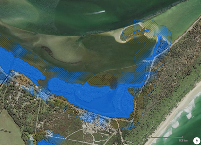
Example of coastal wetland mapping.
Environmental Protection Works
Environmental Protection Works (as defined in the Local Land Services Act 2013) includes:
- Re-vegetation or bush regeneration works
- Wetland protection works
- Erosion protection works
- Dune restoration works
- Ecological burning, and
- Controlling weeds.
but does not include ‘coastal protection works’ (as defined in the Coastal Management Act 2016), meaning:
- Beach nourishment activities or works, and
- Activities or works to reduce the impact of coastal hazards on land adjacent to tidal waters, including (but not limited to) seawalls, revetments, and groynes.
Environmental Protection Works which take place within a coastal wetland or littoral rainforest will require the submission of a Development Application to your local council, however under cl. 27 of the Resilience and Hazards SEPP, will not require an Environmental Impact Assessment to be included.
1 Exclusions to the requirement to obtain designated development approval may apply under Part 2, Division 1 of State Environmental Planning Policy (Resilience and Hazards) 2021.
Step 3: Are the Works Exempt or Complying Development or Works Permitted Without Consent?
| Yes | No |
|---|---|
No further assessment may be required if the works are classified as exempt development. If the works are permitted without consent, development consent is not required. However, potential environmental impacts may still be required to be considered. If the works are classified as complying development, a complying development certificate must also be obtained in addition to considering potential environmental impacts prior to undertaking the works. | The works are likely to require the preparation of a development application. |
Not sure?
Exempt Development and Development Permitted without Consent
You do not need planning or construction approval for many minor and low-impact works (exempt development). Council approval is not needed if your project meets specific development standards.
A list of exempt development types is provided within Part 2 of State Environmental Planning Policy (Exempt and Complying Development Codes) 2008.
A further list of exempt development and development permitted without consent in relation to infrastructure works is detailed within State Environmental Planning Policy (Transport and Infrastructure) 2021. Of relevance to riparian and in-stream works are: Division 7 - Flood mitigation work, Division 19 - Soil conservation works, Division 20 - Stormwater management systems and Division 25 - Waterway or foreshore management activities.
Complying Development
Complying development is a combined planning and construction approval for straightforward development that can be determined through a fast-track assessment by a council or private certifier.
A list of complying development types is provided from Part 2 Subdivision 6 of State Environmental Planning Policy (Exempt and Complying Development Codes) 2008.
A further list of complying development in relation to infrastructure works is detailed within State Environmental Planning Policy (Transport and Infrastructure) 2021. However, note that many activities under State Environmental Planning Policy (Transport and Infrastructure) 2021 apply only to ‘public authorities’.2
Note that State Environmental Planning Policy (Transport and Infrastructure) 2021 also contains additional consultation and consent requirements associated with works which may:
- Have a substantial impact on storm water management services provided by a council,
- Is likely to generate traffic to an extent that will strain the capacity of the road system in a local government area,
- Involves connection to, and a substantial impact on the capacity of, any part of a sewerage system owned by a council,
- Involves connection to, and use of a substantial volume of water from, any part of a water supply system owned by a council,
- Involves the installation of a temporary structure on, or the enclosing of, a public place that is under a council’s management or control that is likely to cause a disruption to pedestrian or vehicular traffic that is not minor or inconsequential, or
- Involves excavation that is not minor or inconsequential of the surface of, or a footpath adjacent to, a road for which a council is the roads authority under the Roads Act 1993 (if the public authority that is carrying out the development, or on whose behalf it is being carried out, is not responsible for the maintenance of the road or footpath.
- In the above instances, the following consultation is required under State Environmental Planning Policy (Transport and Infrastructure) 2021:
- Take into consideration any response to the notice that is received from the council within 21 days after the notice is given.
- Give written notice of the intention to carry out the development (together with a scope of works) to the council for the area in which the land is located
- Is likely to affect the heritage significance of a local heritage item, or of a heritage conservation area, that is not also a state heritage item, in a way that is more than minor or inconsequential, and may be carried out without consent under State Environmental Planning Policy (Transport and Infrastructure) 2021
- In the above instance, the following consultation is required under the State Environmental Planning Policy (Transport and Infrastructure) 2021:
- Prepare a heritage impact assessment
- Give written notice of the intention to carry out the development, with a copy of the assessment and a scope of works, to the council for the area in which the heritage item or heritage conservation area (or the relevant part of such an area) is located; and
- Take into consideration any response to the notice that is received from the council within 21 days after the notice is given.
- Development on flood liable land, that will change flood patterns other than to a minor extent, and may be carried out without consent under State Environmental Planning Policy (Transport and Infrastructure) 2021
- In the above instance, the following consultation is required under State Environmental Planning Policy (Transport and Infrastructure) 2021:
- Give written notice of the intention to carry out the development (together with a scope of works) to the council and the State Emergency Service for the area in which the land is located; and
- Taken into consideration any response to the notice that is received from the council and the State Emergency Service within 21 days after the notice is given.
- Development on land that is within a coastal vulnerability area and is inconsistent with a certified coastal management program that applies to that land
- In the above instance, the following consultation is required under State Environmental Planning Policy (Transport and Infrastructure) 2021:
- Give written notice of the intention to carry out the development to the council for the local government area in which the land is located; and
- Take into consideration any response to the notice that is received from the council within 21 days after the notice is given
- Working adjacent to an aquatic reserve or Marine Park declared under the Marine Parks Act 1997,
- Development in the foreshore area within the meaning of the Sydney Harbour Foreshore Authority Act 1998,
- Development on defence communications facility buffer land within the meaning of clause 5.15 of the Standard Instrument—the Secretary of the Commonwealth Department of Defence.
- Development on land in a mine subsidence district within the meaning of the Mine Subsidence Compensation Act 1961; and
- Development comprising a fixed or floating structure in or over navigable waters.
- In the above instance, the following consultation is required under State Environmental Planning Policy (Transport and Infrastructure) 2021:
- Give written notice of the intention to carry out the development (together with a scope of works) to the relevant public authority in relation to the development; and
- Take into consideration any response to the notice that is received from that authority within 21 days after the notice is given.
2 public authority (in accordance with Clause 1.4 of the Environmental Planning and Assessment Act 1979) means:
(a) a public or local authority constituted by or under an Act, or
(b) a Public Service agency, or
(c) a statutory body representing the Crown, or
(d) a Public Service senior executive within the meaning of the Government Sector Employment Act 2013, or
(e) a statutory State-owned corporation (and its subsidiaries) within the meaning of the State Owned Corporations Act 1989, or
(f) a chief executive officer of a corporation or subsidiary referred to in paragraph (e), or
(g) a person prescribed by the regulations for the purposes of this definition.
Step 4: Development Application
Where riparian and in-stream works are not classified as exempt development, complying development or development permitted without consent as detailed within Step 3, a development application (DA) may be required under Part 4 of the Environmental Planning and Assessment Act 1979 (EP&A Act).
Under the EP&A Act, all DAs must be formally assessed by the relevant council (or the Minister for Planning or delegate in the case that an Environmental Impact Statement (EIS) is required to be prepared). This means that the site must be inspected, applicants and neighbours engaged, reports drafted, and recommendations made.
The six matters that council must consider (under section 4.15 of the EP&A Act) are:
- All plans and policies that apply including State Environmental Planning Policies, Local Environmental Plans and Development Control Plans.
- Impacts of the proposal on the natural and built environment and the social and economic impacts in the locality.
- The suitability of the site for the proposal (e.g., physical characteristics, availability of access and services).
- Any submissions (such as from neighbours or other groups).
- Any comments or agreements/approvals from any NSW Government agency.
- The broader public interest.
Read more about development applications or by contact your local council for more information.
Matters which may be required to be considered as part of a development application are included within Steps 5 - 13.
Landowner’s Consent
If the land subject of the proposal is not owned by the proponent, then Landowner’s Consent must be obtained prior to lodging a Development Application with the Local Council. For example, if this is Crown land/waterway/road contact Crown Lands on 1300 886 235 or email cl.enquiries@crownland.nsw.gov.au
Integrated Development
Integrated development is development that requires both development consent and one or more other approvals from other public authorities (e.g., DPIRD-Fisheries) before consent can be granted. Integrated development applications require a permit listed in section 91 of the EP&A Act (e.g., heritage impact permit, a permit under the Fisheries Management Act 1994 or a Controlled Activity Approval under the Water Management Act 2000). The need for such permits may be assessed through consideration of Steps 5 - 10 of this guideline.
The consent authority must refer the development application to the relevant public authority and incorporate the public authority’s general terms of approval. It must not approve the development application if the agency recommends refusal (DPE 2022).
Environmental Impact Statements
In some instances, for example where there will be an impact to mapped coastal wetland or littoral rainforest (if the works are not environmental protection works) as detailed within Step 2 of this guideline, an environmental impact statement (EIS) will be required to accompany an application for development consent. An EIS is a publicly available document that provides information on a project, including its environmental impacts and mitigation measures, and is used to inform development consent decisions.
Activities for which an EIS is required are outlined within Part 5, Division 5.1, Subdivision 3 of the Environmental Planning and Assessment Act 1979.
Prior to developing an EIS, you will be required to seek Planning Secretary’s Environmental Assessment Requirements (SEARs). This will require the completion of a ‘SEARs request form’ and submission to DPE.
Step 5: Are the Works a Controlled Activity?
| Yes | No |
|---|---|
Seek Controlled Activity Approval. Refer to information in this section. |
Not sure?
Controlled activities are actions carried out on waterfront land, as defined in the Water Management Act 2000. You must obtain an approval from DPE Water to carry out activities on waterfront land unless you have an exemption .
Waterfront land is defined as the bed of any river, lake or estuary, and the land on each side within 40 metres of the riverbank, lake shore or estuary’s mean high-water mark as shown within the illustration below.
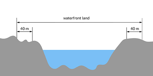
Waterfront land.
Note: the waterfront land diagram is for illustration purposes only. Please refer to the Waterfront Land e-tool for more information on how to determine the high bank for your proposed project.
Controlled activities are:
- Erecting a building,
- Carrying out works,
- Removing material from waterfront land, such as plants or rocks,
- Depositing material on waterfront land, such as gravel or fill; and
- Any activity which affects the quantity or flow of water in a water source.
Examples of controlled activities include:
- Modifications to a watercourse, such as erosion control works and channel realignment,
- Construction of bed control measures,
- Construction of watercourse crossings such as bridges, causeways and bed level crossings, and ancillary works, such as roads,
- Construction of stormwater outlets and spillways,
- Construction of boat ramps and sea walls,
- Laying pipes and cables; and
- Sand and gravel extraction.
Note: Digging holes for tree planting should be a low impact/low disturbance activity with minimal risk to waterfront land and will not require a CAA under the Water Management Act. Provided the planting does not trigger the dredging and reclamation provisions of s198 to 202 of the FM Act or s205 a fisheries permit will not be required
DPE Water has a Waterfront land e-tool to help you determine whether the site of your proposed project is classed as waterfront land. For more information, see the Waterfront land e-tool fact sheet.
To find out more about controlled activities, including what exemptions apply, see Working on waterfront land fact sheet.
There are several exemptions from the need to obtain a controlled activity approval, such as:
- For major projects which are state significant development or state significant infrastructure,
- In certain circumstances specified in the regulations, for example:
- Activities carried out by public authorities,
- Activities carried out by network operators in certain circumstances,
- Certain types of activities to enable a person to take water under their domestic and stock rights, such as installing a water pump and water pipe,
- Constructing and using a harvestable rights dam; and
- Activities relating to a residential dwelling in certain circumstances.
For more information refer to the Controlled activity approval exemptions factsheet.
NRAR has developed a simple web-based tool to help you identify if an exemption applies to your proposal.
The tool will help you:
- Identify if an exemption applies,
- Interpret the requirements and limitations of exemptions
- Send you an email containing your answers and a result.
Streamlined Assessment
Where applications for a Controlled Activities Approval are presented in accordance with the riparian corridor matrix (Table 1) and other DPE Water controlled activity guidelines, they will be assessed under a streamlined process. This may decrease the amount of time it takes the Office of Water to make a determination, saving applicants time and money.
Applications that do not conform to the matrix and/or relevant DPE Water controlled activity guidelines will continue to be subject to merit assessment to ensure that the proposals meet the requirements of the WM Act. All applications will still need to demonstrate that minimal harm will occur to waterfront land before a controlled activity approval will be issued.
For more information download the Licensing approvals controlled activities factsheet.
Table 1. Recommended riparian corridor (RC) widths
| Watercourse type | VRZ width | Total RC width |
|---|---|---|
| 1st order | 10 meters | 20 meters + channel width |
| 2nd order | 20 meters | 40 meters + channel width |
| 3rd order | 30 meters | 60 meters + channel width |
| 4th order and greater (includes estuaries, wetlands and any parts of rivers influenced by tidal waters) | 40 meters | 80 meters + channel width |
Step 6: Do the Works Impact Upon an Area Subject to Coastal Management Considerations?
| Yes | No |
|---|---|
Undertake relevant consideration and seek approvals as required. Refer to information in this section. |
Not sure?
Two key pieces of legislation regulate coastal management in NSW:
The Coastal Management Act 2016 (CM Act) - establishes the framework and overarching objects for coastal management in NSW. The CM Act defines the coastal zone, comprising 4 coastal management areas:
- Coastal wetlands and littoral rainforests area (also refer to Step 2),
- Coastal vulnerability area,
- Coastal environment area; and
- Coastal use area.
The CM Act establishes management objectives specific to each of these management areas, reflecting their different values to coastal communities.
State Environmental Planning Policy (Resilience and Hazards) 2021 - identifies and maps the coastal zone according to definitions in the CM Act. The Resilience and Hazards SEPP identifies development controls for consent authorities to apply to each coastal management area to achieve the objectives of the CM Act.
The Resilience and Hazards SEPP also establishes the approval pathway for coastal protection works.
Statewide mapping is available for:
- Coastal wetlands and littoral rainforest area,
- Coastal environment area; and
- Coastal use area.
The provisions of the above legislation must be considered in relation development applications (Step 4) as applicable. To confirm if the above coastal management areas and zones apply to your project refer to the NSW Governments ePlanning Spatial Viewer.
Further information on the NSW coastal management framework can be obtained from NSW Department of Planning and Environment website.
Step 7: Do the works impact upon key fish habitat and/or fish passage?
| Yes | No |
|---|---|
Seek approval under the Fisheries Management Act 1994. Refer to information in this section. |
Not sure?
Approval under the Fisheries Management Act 1994 (FM Act) may be required for activities which impact key fish habitat such as:
- Dredging or reclamation works, i.e., excavating, digging, or placing material on or within key fish habitat (Section 199 - 201),
- Harming (cut, remove, damage, destroy, shade etc) of marine vegetation (mangroves, seagrass, and seaweeds) (Section 205); and
- Obstructing the free passage of fish (Section 219).
One of the objectives of the Fisheries Management Act 1994 is to 'conserve key fish habitats'. DPIRD-Fisheries has defined 'Key Fish Habitats' to guide the compilation of maps to include all marine and estuarine habitats up to highest astronomical tide level (that reached by 'king' tides), Coastal Wetlands and most permanent and semi-permanent freshwater habitats including rivers, creeks, lakes, lagoons, billabongs, weir pools and impoundments up to the top of the bank. Small headwater creeks and gullies (known as first and second order streams), that only flow for a short period after rain are generally excluded, as are farm dams constructed on such systems. Wholly artificial waterbodies such as irrigation channels, urban drains and ponds, salt and evaporation ponds are also excluded except where they are known to support populations of threatened fish or invertebrates.
Key Fish Habitat Mapping data is available to view and download at the Fisheries Spatial Data Portal. Potential Impact on key fish habitat should be considered during assessment of any given riparian or in-stream works project.
Dredging, reclamation and obstruction of fish passage
Dredging and reclamation incorporates excavation or placement of material within key fish habitats and any other land prescribed by the Fisheries Management Regulations. Further information on key fish habitat can be found within Table 1 ((page 18) of the Department Primary Industries and Regional Development (Fisheries) Policy and guidelines for fish habitat conservation and management (Update 2013)
Dredging work is defined under the FMA & FM(G) Regulation as:
(a) any work that involves excavating water land3, or
(b) any work that involves moving material on water land or removing material from water land that is prescribed by the regulations as being dredging work, which includes:
(i) work that involves the removal of woody debris, snags, gravel beds, cobbles, rocks, boulders, rock bars or aquatic vegetation4 from water land,
(ii) work that involves the removal of any other material from water land that disturbs, moves, or harms woody debris, snags, gravel beds, cobbles, rocks, boulders, rock bars or aquatic vegetation,
(iii) work that involves moving woody debris, snags, gravel beds, cobbles, rocks, boulders, rock bars or aquatic vegetation on water land.
Obstruction of fish passage incorporates placement of any material or obstruction which could block fish movement.
Prior to carrying out or authorising any dredging or reclamation work, a Public Authority (not including a local government authority) must notify Department of Primary Industries and Regional Development (Fisheries) of the proposed work and consider any matters concerning the proposed work that are raised within 21 days (or other agreed timeframe - see 199 FM Act). The public authority is not required to obtain a permit under the FM Act, however, must consult with Department of Primary Industries and Regional Development (Fisheries) prior to undertaking any work.
Any dredging or reclamation work carried out by a public authority is exempt from the requirement to consult with Department of Primary Industries and Regional Development (Fisheries), if the work is carried out in accordance with the Code of Practice for Minor Works in NSW Waterways. Note this only applies to certain work being undertaken by the public authority, and consultation may still be required for works outside of this scope. This also does not apply to works being authorised by the public authority (consultation required).
A person (s201) or local government authority (s200) must not carry out dredging or reclamation work without a permit issued by Department of Primary Industries and Regional Development (Fisheries). However, this does not apply to work that have been authorised under the Crown Land Management Act, or by a relevant public authority (as per s199 above).
Prior to undertaking any activity that may obstruct fish passage, in accordance with s219 of the FM Act, a person must seek a permit from the Department of Primary Industries and Regional Development (Fisheries).
Marine Vegetation and Key Fish Habitat
Marine vegetation, such as mangroves and seagrass, is critical to the functioning of marine environments. Prior to undertaking any activity that would harm marine vegetation, in accordance with FM Act, a permit must be sought from the Department of Primary Industries and Regional Development (Fisheries) (s205).
In addition, many fish and marine vegetation species are protected under the FM Act and other relevant legislation. The potential for such species to exist within your project area must be considered in order to determine if any impact to these species might occur, and to identify any mitigation measures or change to the project which may be required. A list and description of threatened fish and marine species are listed on the Department of Primary Industries Regional Development (Fisheries) website. Freshwater threatened fish species distribution maps can also be found on the Department of Primary Industries and Regional Development (Fisheries) Spatial Data Portal. You can also consider the potential for your project to impact upon these species through using the online resources.
More information about activities requiring a permit visit NSW DPIRD's Council and Developer Toolkit.
Other Department of Primary Industries and Regional Development (Fisheries) publications that may be relevant to your project that could also be considered include ‘Policy and guidelines for fish habitat conservation and management’. This and other relevant publications are available on the Department of Primary Industries and Regional Development (Fisheries) website.
Marine Parks
If your proposed works is located within a NSW Marine Park, it is recommended that you contact the Marine Park Manager to discuss the proposed works and confirm if a permit under the Marine Estate Management Act will be required.
3 Land submerged by water, whether permanently or intermittently, or whether forming an artificial or natural body of water, and includes wetlands and any other land prescribed by the regulations
4 Aquatic vegetation means native vegetation that inhabits freshwater
Step 8: Do the Works Impact Upon Aboriginal Object(s) or Declared Aboriginal Place(s)?
| Yes | No |
|---|---|
Seek approval under the National Parks and Wildlife Act 1974. Refer to information in this section. |
Not sure?
To understand if your project may impact upon Aboriginal object(s) or declared Aboriginal Place(s) refer to the Due Diligence Code of Practice for the Protection of Aboriginal Objects in New South Wales.
To assist in identifying if Aboriginal object(s) or declared Aboriginal Place(s) may occur within the vicinity of your project, you can undertake a search of the Aboriginal Heritage Information Management System (AHIMS).
If you are planning an activity where harm to an Aboriginal object or declared Aboriginal Place cannot be avoided, you will need to apply for an Aboriginal Heritage Impact Permit (AHIP).
Step 9: Do the Works Impact Upon Non-Aboriginal Heritage?
| Yes | No |
|---|---|
Seek approval under the Heritage Act 1977. Refer to information in this section. |
Not sure?
To make alterations to State Heritage Register items (places and objects) you will need to meet the criteria for an exemption or apply and be granted approval.
This refers to carrying out works that are:
- On or within the curtilage of an item listed on the State Heritage Register (SHR); or
- On or within the curtilage of a place with an Interim Heritage Order (IHO) - which is treated like an SHR item.
Under section 57 of the Heritage Act 1977, approval is needed before carrying out any of the following works:
- Demolish the building or work,
- Damage or despoil the place, precinct, or land, or any part of the place, precinct or land,
- Move, damage, or destroy the relic or moveable object,
- Excavate any land for the purpose of exposing or moving the relic,
- Carry out any development in relation to the land on which the building, work or relic is situated, the land that comprises the place, or land within the precinct,
- Alter the building, work, relic, or moveable object,
- Display any notice or advertisement on the place, building, work, relic, moveable object, or land, or in the precinct; or
- Damage or destroy any tree or other vegetation on, or remove any tree or other vegetation from, the place, precinct, or land.
There are various types of exemptions and approvals that may apply depending on the nature of your proposal.
Before you apply
Check the status of your item
Check the State Heritage Inventory to confirm the item is listed on the State Heritage Register or has an Interim Heritage Order.
If yes, usually you will submit an application for approval with Heritage NSW. But for some items or local government areas, other delegations apply. Refer to the Delegations page for more information.
Check if your proposal meets the criteria for an exemption
Some minor works that will have no impact on the heritage significance of an SHR or IHO item do not require approval.
Refer to the Standard Exemptions page to determine whether your proposal fits into this category.
Site specific exemptions may also apply for the heritage item. Check the ‘Procedures/Exemptions’ section of the State Heritage Inventory entry to determine if there are any site-specific exemptions for the item.
Exemptions are granted under section 57 of the Heritage Act 1977.
In addition to the above, if you are planning to carry out excavation that may harm or disturb historical archaeological relics for historical archaeology purposes, there are some of the requirements you will need to consider. There are also certain assessments and reporting practices you must undertake for compliance under the Heritage Act 1977 before investigating and reporting on archaeology.
Additional information regarding the identification and management of Non-Aboriginal Heritage, (including maritime heritage and heritage on state significant projects) can be found on the NSW Department of Planning and Environment.
Step 10: Do the Works Incorporate Impact to Native Vegetation and/or Endangered, Threatened, Vulnerable or Protected Species, Populations, Ecological Communities or Area of Outstanding Biodiversity Value, or represent a Key Threatening Process?
| Yes | No |
|---|---|
Seek approval under the Local Land Services Act 2013, the Biodiversity Conservation Act 2016, the NSW Vegetation SEPP and/or the Fisheries Management Act 1994 as applicable. Refer to information in this section. |
Not sure?
Vegetation Clearing
Rural land
Clearing of native vegetation on rural land is legislated by the Local Land Services Act 2013 and the Biodiversity Conservation Act 2016.
Key features of these Acts include:
- Arrangements that allow landowners to improve productivity while responding to environmental risks,
- Ways to assess and manage the biodiversity impacts of rural development,
- A State Environmental Planning Policy for managing impacts on native vegetation in non-rural areas,
- Significant investment to protect high-value vegetation on private land,
- A risk-based system for regulating human and business interactions with native plants and animals; and
- Streamlined approvals and dedicated resources to help reduce the regulatory burden on landholders.
The Land Management Framework includes the following components which work together to regulate native vegetation management on private rural land:
- The Native Vegetation Regulatory Map identifies rural land that is regulated under the framework,
- The State Environmental Planning Policy covers land management and impacts on native vegetation in urban and environmental zones and may apply in areas where the Land Management (Native Vegetation) Code 2018 does not,
- The Land Management (Native Vegetation) Code 2018 supports landholders to manage their land to ensure more productive farming methods and systems, while responding to environmental risks. Some clearing under the Code requires land to be set aside, and listed on a public register.
Allowable activities under the Local Land Services Act 2013 cover a range of routine land management activities associated with agriculture and other common practices in rural areas, including environmental protection works. Landholders do not need to seek approval for allowable activities; and
- The Native Vegetation Panel is an independent agency under the Local Land Services Act 2013, with a key function to determine applications to clear native vegetation:
- In rural areas that don’t meet conditions under allowable activities or the Code; or
- In non-rural areas that exceed the Biodiversity Offsets Scheme Threshold.
Urban areas and land zoned for environmental protection
Clearing of native vegetation in urban areas and land zoned for environmental protection, where the clearing is not linked to a development application, is legislated by the State Environmental Planning Policy (Biodiversity and Conservation) 2021. The Biodiversity and Conservation SEPP ensures that if the clearing of native vegetation on land zoned for urban or environmental purposes exceeds entry thresholds the Biodiversity Offset Scheme will apply. The Biodiversity and Conservation SEPP also allows councils to manage vegetation clearing in their local area through a permit system.
Where linked to a development application, consult with your local council or the Department of Planning and Environment (DPE) in relation to considerations that need to be considered as part of the development application process.
Biodiversity Offsets Scheme (BOS)
The Biodiversity Offsets Scheme (BOS) manages and calculates offsets for all types of development that are likely to have a significant impact on biodiversity. It also establishes biodiversity stewardship agreements, which are voluntary in-perpetuity agreements entered into by landholders, to secure offset sites.
The requirements for landholders under the Scheme are assessed using the Biodiversity Assessment Method.
After the assessment, there may be offsets for (or payments due from) the landholder. The assessment must be carried out by an accredited assessor. Find an accredited assessor.
The Biodiversity Offsets Scheme may be triggered if there is likely to be a significant impact on threatened species, ecological communities, or their habitats, from works associated with a riparian or in-stream project. Read more information on the Biodiversity Offsets Scheme.
Endangered, Threatened, Vulnerable or Protected Species, Populations, Ecological Communities and Areas of Outstanding Biodiversity Value
The potential for Endangered, Threatened, Vulnerable or Protected Species, Populations, Ecological Communities or Areas of Outstanding Biodiversity Value (formerly known as Critical Habitat) must also be considered. This can include impact to both terrestrial and aquatic flora and fauna and may require approval from the Environment, Energy and Science Group of the Department of Planning and Environment, or Department of Primary Industries and Regional Development (Fisheries) as applicable.
Threatened Species Test of Significance
The threatened species test of significance is one of the triggers used to determine if a development or activity is likely to significantly affect threatened species or ecological communities, or their habitats.
The test of significance is applied as part of the Biodiversity Offsets Scheme entry requirements and is set out in section 7.3 of the Biodiversity Conservation Act 2016.
The test of significance allows applicants and proponents to undertake a qualitative analysis of the likely impacts and determine whether further assessment is required. All factors must be considered, and an overall conclusion must be drawn from all factors in combination.
Parts (a), (b) and (c) of the test are applied to species and ecological communities listed in Schedules 1 and 2 of the Biodiversity Conservation Act 2016.
The applicant or proponent should develop a list of threatened species and ecological communities which may be affected directly or indirectly by the proposed development or activity. The list of potential species should be provided to the consent authority or the determining authority along with the test of significance. Reasons should be provided to show how the list was derived.
Part (d) of the test of significance concerns the effect on any areas declared to be of outstanding biodiversity value under Part 3 of the Biodiversity Conservation Act 2016.
If a proposed development or activity is carried out on a declared area of outstanding biodiversity value (AOBV), it is automatically taken to be likely to significantly affect threatened species. The development or activity will be subject to the biodiversity offsets scheme regardless of the outcome of any test of significance.
Part (e) of the test of significance is to consider key threatening processes listed in Biodiversity Conservation Act 2016. The applicant or proponent should develop a list of key threatening processes that the proposed development or activity may contribute towards. Reasons should be provided to show how the list was derived.
For further guidance on how to interpret and apply the factors of the test of significance please refer to the Threatened Species Test of Significance Guidelines.
If a proposed development under Part 4 of the Environmental Planning and Assessment Act 1979 is likely to significantly affect threatened species, a biodiversity development assessment report must be prepared by an accredited assessor. The biodiversity offsets scheme will apply.
Species Impact Statements
Should a proposal include actions that are considered likely to harm a threatened species, population, or ecological community, damage a critical habitat, or damage a habitat of a threatened species, population or ecological community under the Fisheries Management Act 1994, a Species Impact Statement will be required to be prepared, and subsequent application for a Licence from the Department of Primary Industries and Regional Development (Fisheries). An approval for such actions may only be issued for scientific purposes, for the welfare of fish or marine vegetation, or if there is a threat to life or property.
The requirements of a species Impact statement (SIS) are set out in section 220ZX of the Fisheries Management Act 1994. For important fisheries habitat refer to Step 7.
Biodiversity Development Assessment Report (BDAR)
Should a proposal be found to impact on Areas of Outstanding Biodiversity Value or threatened species as defined by the Biodiversity Conservation Act 2016, a Biodiversity Development Assessment Report (BDAR) will be required to be prepared.
A BDAR is a report required under the Biodiversity Conservation Act and is prepared by an accredited person to apply the biodiversity assessment method (BAM). The BAM is an assessment manual that provides a consistent method for the assessment of biodiversity, including assessing certain impacts on threatened species and threatened ecological communities, their habitats, and impacts on biodiversity values. A BDAR provides guidance on how a proponent can avoid and minimise potential biodiversity impacts and identifies the number and class of biodiversity credits that need to be offset to achieve a standard of 'no net loss' of biodiversity.
The NSW BioNet can be used to assist in considering the potential for Endangered, Threatened, Vulnerable or Protected Species, Populations, Ecological Communities or Areas of Outstanding Biodiversity Value to occur within and adjacent to the project. Threatened fisheries species, their habitat and associated key threatening processes should also be considered for works which may impact upon fisheries habitat.
Koala Habitat Protection
Chapter 4 of the State Environmental Planning Policy (Biodiversity and Conservation) 2021 provides a policy framework for Koala Habitat Protection in 83 Local Government Areas (LGA) in NSW. At this stage:
- In nine of these LGAs – Metropolitan Sydney (Blue Mountains, Campbelltown, Hawkesbury, Ku-Ring-Gai, Liverpool, Northern Beaches, Hornsby, Wollondilly) and the Central Coast LGA – Biodiversity and Conservation SEPP 2021 applies to all land use zones.
- In all other identified LGAs, Biodiversity and Conservation SEPP 2021 does not apply to land zoned RU1 Primary Production, RU2 Rural Landscape or RU3 Forestry.
The principles of the Biodiversity and Conservation SEPP 2021 are to:
- Help reverse the decline of koala populations by ensuring koala habitat is properly considered during the development assessment process.
- Provide a process for councils to strategically manage koala habitat through the development of koala plans of management.
Where it applies, the State Environmental Planning Policy (Biodiversity and Conservation) 2021 aims to encourage proper conservation and management of areas of natural vegetation that provide habitat for koalas to ensure a permanent free-living population over their present range and reverse the current trend of koala population decline by:
- Requiring the preparation of plans of management before development consent can be granted in relation to areas of core koala habitat, and
- Encouraging the identification of areas core koala habitat; and
- Encouraging the inclusion of areas of core koala habitat in environment protection zones. The policy identifies areas of potential and core koala habitat as:
- Potential koala habitat is defined as areas of native vegetation where the trees of the types listed in Schedule 2 constitute at least 15% of the total number of trees in the upper or lower strata of the tree component.
- Core koala habitat is defined as an area of land with a resident population of koalas, evidenced by attributes such as breeding females (females with young) and recent sightings of and historical records of a population.
The above Biodiversity and Conservation SEPP must be considered in relation to any proposal which triggers the SEPPs.
Land Subject to a Conservation Agreement
In addition to the above considerations, working within an area that is subject to a conservation agreement entered into under the National Parks and Wildlife Act 1974 may also require approval from the National Parks and Wildlife Service.
Biodiversity Conservation Licences
If a proposal does not require approval under the EP&A Act or the SEPP (Biodiversity and Conservation) 2021, then a threatened species licence, a class of biodiversity conservation licence under Part 2 of the Biodiversity Conservation Act 2016, may be required if the proposal involves an action that is likely to result in:
- harm to an animal that is a threatened species or part of a threatened ecological community
- picking a plant that is a threatened species or part of a threatened ecological community
- damage to the habitat of a threatened species or threatened ecological community
- damage to a declared area of outstanding biodiversity value.
Note: also refer to Step 11 in relation to potential impacts to Matters of National Environmental Significance.
Key Threatening Processes
A threat may be listed as a key threatening process under the NSW Fisheries Management Act 1994 if it:
(a) it adversely affects threatened species, populations, or ecological communities, or
(b) it could cause species, populations or ecological communities that are not threatened to become threatened.
Key threatening processes are also listed in the Threatened Species Conservation Act, and include the things that threaten - or could threaten - the survival or evolutionary development of species, populations, or ecological communities, including:
- Pest animals
- Weeds
- Diseases
- Habitat loss/change.
Step 11: Do the Works Impact Upon Matters of National Environmental Significance?
| Yes | No |
|---|---|
Seek approval under the Environment Protection and Biodiversity Conservation Act 1999. Refer to information in this section. |
Not sure?
The matters of national environmental significance protected under national environment law include:
- Listed threatened species and communities,
- Listed migratory species,
- Ramsar wetlands of international importance,
- Commonwealth marine environment,
- World heritage properties,
- National heritage places,
- The Great Barrier Reef Marine Park,
- Nuclear actions; and
- A water resource, in relation to coal seam gas development and large coal mining development.
The Australian Governments significant impact guidelines provide overarching guidance on determining whether an action is likely to have a significant impact on a matter protected under national environment law, being the Environment Protection and Biodiversity Conservation Act 1999. Access the guidelines.
You can use the Australian Government’s Protected Matters Search Tool to assist in identifying any matters of national environmental significance which may apply to your proposal.
Step 12: Other Considerations
In addition to the steps outlined above, other considerations in relation to your project may include:
- Disturbing bushland zoned or reserved for public open space in the Sydney and Gosford metropolitan areas - Review the planning approval pathway against the State Environmental Planning Policy No 19—Bushland in Urban Areas.
- Undertaking earthworks in the Sydney drinking water catchment as defined by State Environmental Planning Policy (Sydney Drinking Water Catchment) 2011 - consult the current recommended practices. Consider whether the project would have a neutral or beneficial effect on water quality.
- Working at sites in which hazardous contamination, asbestos or asbestos containing materials exist - determine whether a licence and/or approval is required from SafeWork NSW and/or the Environment Protection Authority.
- The presence of any invasive weeds listed in appendices of relevant local Regional Weeds Plan.
- Permission required from Water NSW to build an erosion control dam
- Determine if third or above stream – if so cannot build
- Understand and quantify the harvestable rights that apply to the property
- Check with local council regulations to determine restrictions that may apply
- If still want more retention, then apply for license with Water NSW.
Step 13: Stakeholder Consultation
During the planning and assessment phase of your project, consultation is likely to be required with key project stakeholders to communicate the details of your proposal and to seek feedback. These stakeholders may include Government agencies (local, State or Federal), Local Aboriginal land Council(s), Native Title groups, community stakeholders (such as potentially effected residents and businesses) and industry stakeholders (such as recreational or commercial fishing groups) as applicable.
Minimum stakeholder consultation requirements are generally outlined within the respective legislation, regulations and guidelines that apply to any particular approval pathway. This consultation will likely be administered through the relevant determining authority, such as a local council or the Department of Planning and Environment. However, in some instances you may choose to proactively undertake initial consultation with key stakeholders such as landholders, neighbours, relevant regulatory authorities and interest groups who may be impacted upon by your proposal. This consultation can be used to seek clarification and/or to support your assessment and application. Adequate time (generally between 14 and 28 days depending on the nature and scale of the project) should be provided to allow stakeholders to consider the proposal and to provide input.
There are a variety of methods used to undertake consultation and to seek feedback (for example through contacting your local council or relevant Government Department through details provided on their website). However, when seeking formal submissions or agreements to a proposal (as applicable), it is recommended that such a submission or agreement be sought and received in writing.
Note that where the NSW Planning Portal is required to be used in the submission of a development proposal, referral, or provision of information via the Planning Portal may be required in addition to any other forms of consultation.