Gully erosion assessment and control guide
This guide is designed to assist members of the community to understand gully erosion and follow best practice to mitigate the impacts of erosion.
Depending on the knowledge of the reader, the information and advice in this guide should be used as a starting point, with professional and local advice sought in relation to the design of control works.
What is gully erosion?
Erosion is the movement of material via the activity of wind and/or water. This is a natural process which has over time shaped the landscape features seen today, such as river valleys and mountain ranges. One of the most common and visual forms of erosion is gully erosion.
Gully erosion is the removal of soil from surface and sub-surface, creating permanent channels greater than 30cm deep. Once a gully is formed, erosion can continue in three ways:
- The gully flood can deepen until rock is exposed or the grade becomes flat enough that the flow velocity is too slow to erode the soil any further.
- The banks undercut causing them to collapse and wash away. Sidewalls can also simply erode or melt away in very dispersible soil types.
- The gully head can cut back up the slope or other gully heads form on the side of the gully (lateral gullies) as water flows over the edge.
In some gully systems these processes can occur concurrently.
What causes gully erosion?
Gully erosion often begins as a small ‘nick point’ which are shallow and discontinuous. These points slowly get larger until they begin to join up, creating larger, continuous gullies.
These ‘nick points’ often occur where groundcover has been disturbed by any number of natural or unnatural events.
Groundcover is the key to stabilisation. A reduction in groundcover can expose bare soil leading to higher run off volumes and velocity of these flows. Gullies often form as a result of disturbance that has led to a change in the groundcover. For example, stock tracks reduce both the protective groundcover and concentrate water flow.
Property layout should consider the location of vehicle tracks, fence lines, watering points and gateways with respect to their influence on stock movement and the potential to initiate erosion and gully development.
What influences the rate of gully erosion?
Factors that impact directly on the development of gully erosion are groundcover, erodibility of soils and volume and velocity of flows. The following influences these factors:
- rainfall / runoff
- trickle flow
- soil type
- slope and topography
- land use.
Other factors including for agricultural purposes, construction (road and rail), development and forestry can also impact, and in many cases, accelerate gully erosion.
What are some of the impacts caused by gully erosion?
Gullies can interfere with many aspects of farming including:
- cultivation
- mustering stock
- general access
- water supply
- infrastructure damage and maintenance
- soil loss
- draining the landscape
- changing the aesthetic of the landscape.
Sediment transported from gullies may be deposited in dams leading to a reduction in capacity and often has impacts on drainage and infrastructure such as the blocking of pipes and culverts.
Sediment mobilised in drinking water catchments by erosion can reduce water quality, while also degrading the habitat for aquatic plants and animals.
How can I prevent erosion?
Ensuring you have adequate levels of groundcover is the most effective way to minimise run-off and erosion. By reducing run-off, more water is made available for plant and pasture growth. By reducing erosion, soil, nutrients, and organic matter are retained in place and siltation problems are minimised.
The prevention of soil erosion depends on managing the soil in such a way that it is retained on site and can be used for its productive purpose. Where the soil is left unprotected, up to 100 tonnes/hectare of valuable topsoil can be lost in a year (1 mm depth of soil over one hectare weighs around 10 tonnes).
Developing an erosion control plan that considers such factors as land capability, systems of management, location of improvements and specific erosion control measures provides a good starting point.
Some factors that need consideration when wanting to prevent erosion include:
- land capability – is the land suitable for cultivation, grazing, timber, rural production etc.
- management systems – recognising the complementary role land management and earthworks play
- strategic pasture management – resting pastures, groundcover levels above 70%, control of total grazing pressure, crop rotation, weed control
- location of infrastructure – including roads/farm tracks, fences, gates and watering points
- farm planning – location of permanent features, consideration of natural resources such as soil type and vegetation, issues such as gully erosion, salinity, water and access issues, and planned improvements and projects.
By factoring in the above, when it comes to preventing erosion you will be able to potentially address several issues at once.
How do I undertake an assessment of gully erosion?
Correctly assessing your gully erosion will allow you to identify priority projects and undertake the most appropriate mitigation and improvement works. It may also provide you with opportunities to seek funding support to carry out mitigation and improvement works.
The assessment is a four-step process:
1. Assessment of gully erosion
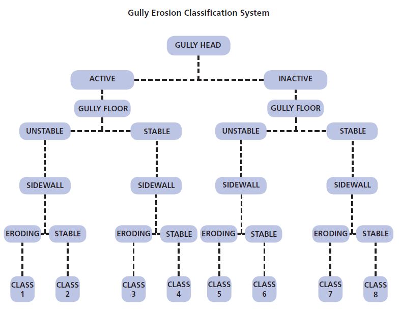
Inspect the gully to determine which components are stable or active. The three components to consider are the gully head, gully floor and gully sidewalls.
2. Allocation of gully erosion class rating
Using the gully erosion classification system, assess the gully and allocate an erosion class rating (class one to class eight, with class one being the most active and unstable and class eight being the most inactive and stable gully). A gully erosion class rating can be determined from assessing the stability of the components of the gully.
Gullies with an erosion class of one to four will generally require earthworks to stabilise the active gully head. Gully erosion classes five to eight generally have a stable gully head and require management options to deactivate either the gully walls or gully floor or both of these components.
3. Identification of options for gully erosion management
There are a variety of management options for stabilising active gullies and reducing the amount of sediment entering our waterways. If earthworks are recommended, seek advice on the design, construction and maintenance of such works.
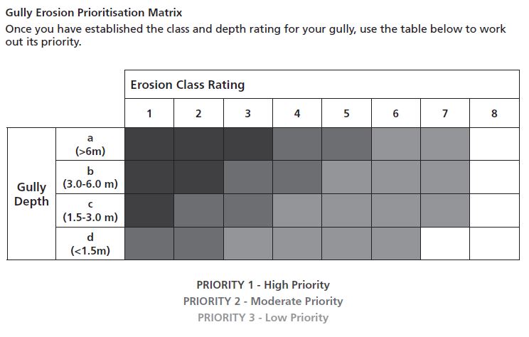
4. Prioritisation of gully rehabilitation for water quality and off-site benefit
Working out which gullies are higher priorities for treatment can be complicated and a site-specific task. The bigger and more active gullies will contribute higher sediment and associated nutrient loads in the watercourse, and therefore have potentially greater downstream water quality impacts.
The below matrix is an example of a simple way to assess the priority of your gully, using the gully erosion class rating system mentioned in step 2.
What are my earthwork options to control erosion?
Before any treatment is considered, the size of the contributing catchment needs to be determined. Generally, the larger the catchment size, the less options are available. In small catchments (i.e. less than 50 hectares), a variety of earthmoving techniques may be used to stabilise gullies depending on the site characteristics and available funds.
On larger catchments, works will need detailed design to ensure they are capable of handling storm events. In most situations, structures will need to cater for at least a 1 in 50-year storm event.
Some options available for earthworks to control erosion include:
- gully control structure (dam)
- diversion banks
- incline pipes (pipes in banks)
- gulling filling and shaping
- flumes (concrete or rocks)
- grade stabilisation structure (rock ramp)
- v-notch weirs
- strategic fencing.
Prior to undertaking any earthworks, professional advice should be sought on the design, construction and required maintenance. Additionally, it is the individual’s responsibility to ensure all appropriate approvals have been sought and received.
A good place to start is the NSW Department of Planning and Environment-Water Group which is responsible for the approvals of controlled activities on waterfront land including the bed and bank of any river, lake or estuary and all land within 40 metres of the highest bank of the river, lake or estuary: W: www.water.dpie.nsw.gov.au E: waterlicensing.servicedesk@dpie.nsw.gov.au
Want to know more about gully erosion and assessment?
A good place to start is the NSW Department of Planning and Environment-Water Group which is responsible for the approvals of controlled activities on waterfront land including the bed and bank of any river, lake or estuary and all land within 40 metres of the highest bank of the river, lake or estuary:
W: https://www.dpie.nsw.gov.au/waterE: waterlicensing.servicedesk@dpie.nsw.gov.au

